


The latest UN population projections predict that between now and 2050 the world’s population will have grown by 2.5 billion people, and will be one third higher than today. However, the agricultural production systems which are needed to feed this population are coming under greater pressure from climate change, dwindling fossil fuel and mineral resources, and increasing demands on land for crops for biofuels and urban development. The emerging middle classes in Asia, Latin America and Africa will demand a more exciting and varied diet, including more dairy and meat products, placing further pressure on food systems. According to IBM research, global food production must grow by 70% in order to feed this growth.
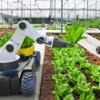
Precision agriculture represents an important suite of technologies which could play an important role in meeting these challenges. It is using technology to make more precise and efficient use of inputs to account for the wide variation in crop, soil and genetics found within individual fields, herds or flocks. Precision crop farming is about making the most efficient use of resources based on site specific conditions, whereas precision livestock farming is optimizing the contribution of each animal.
Dr Gregg Carlson of South Dakota State University recently stated: “Precision farming is conventional farming, but at a different scale. Instead of farming (managing) a 160 acre field we are now managing every square foot of land.”
High tech data collection
There are three elements to a precision agriculture system. Firstly, the means of gathering data either through remote sensing or other means. Secondly, data needs to be processed into a meaningful format such as a field map, or downloaded into software which can be used to support management decisions. And finally, appropriate actions need to be implemented to a specific part of the field or an individual animal. Examples of this might be a variable rate application of fertilizer to different parts of a field depending on nutrient status, or electronic feeders releasing individual rations to dairy cows.
Data is critical in precision agriculture, and information can be collected by a variety of technologies such as in field sensors, satellites or UAVs (Unmanned Aerial Vehicles). The idea of precision agriculture is not new, however advances in IT and computing are only now allowing many of these ideas to be used to their full potential.
Spatial information can be used to determine the optimum levels of inputs across a field, with more tailored use of seed, fertilizer, pesticides and irrigation water achieved by linking data to variable rate applicators. Precision agricultural technology can be used to reduce waste, improve the economic efficiency of farming operations and farmer’s margins; as well as reduce the dependency on fossil fuels, and the environmental impact of farming.
To begin with, a farmer must have a means of collecting data. A farmer can assess crop conditions visually; however, remote sensors can pick up wavelengths of light not visible to the human eye, and this can provide additional information on the crop. Linking sensors to GPS (Global Positioning Satellite) systems can produce detailed and accurate maps of individual fields.
When electromagnetic energy from the sun hits plants the energy can be reflected, absorbed or transmitted. How much light is reflected, absorbed or transmitted at a particular wavelength is determined by features of the plant, such as leaf colours, textures, shapes. The relationships between what is reflected, absorbed or transmitted can be used to determine the spectral signatures of specific species of plants, or whether a plant is healthy or unhealthy. For example, healthy sugar beets have a lower reflectance value in the visible wavelength range between 400 to 700 nm than stressed sugar beets, but this is reversed in the non-visible range between 750 nm and 1200 nm.
Agricultural remote sensors are commonly passive systems which use the energy from the sun; however there are a number of things to consider when choosing a system.
The first consideration is the spatial resolution or the pixel size. A spatial resolution of one metre means each pixel image represents one square metre of the field. The spectral resolution refers to the number of bands—narrow portions of the electromagnetic spectrum. The more bands the system has, the greater the sensitivity, and greater the potential for picking up variations in energy wavelengths and crop conditions. Radiometric resolution refers to the sensitivity of the sensor in picking up reflectance levels. A higher resolution will give a more precise value for the reflectance of a particular portion of the electromagnetic spectrum. The temporal resolution is how often a remote sensor can cover an area. Geostationary satellites can provide continuous sensing, whilst orbiting satellites can only provide data for each time they pass over the field. Aircraft can be used for more frequent monitoring, and can often achieve a smaller spatial resolution, allowing more detailed data to be gathered.
Eyes in the sky
Remote sensors can be used on different platforms, such as satellites, conventional aircraft or UAVs. UAVs or drones are a fast growing area for this work. To many people the term “drone” refers to a weapon system and many in the industry prefer to avoid it. However, the civilian use of UAVs is developing rapidly.
There are a growing number of companies and farmers across the world using this technology in crop production for field mapping and monitoring soil conditions and crops due to the clear cost advantages compared to using manned aircraft for such work. Commercial UAVs are often much smaller than their manned counterparts. Another application might be a farmer in New Zealand using UAVs to count and monitor sheep.
UAVs collect data in high resolution; this, according to the Home Grown Cereals Authority (HGCA) in the UK, means that variations within crops can be compared to the centimetre rather than the metre as with satellite mapping. Depending on the type of sensors used, UAVs may have a range of uses including disease and weed detection, monitoring crop biomass and green leaf area, monitoring responses to fertilizer, detecting water stress, crop scouting, bare soil imagery, irrigation and drainage planning, yield estimation and monitoring, and aerial pathogen spore sampling. Aerial sampling may provide important warnings of disease outbreaks. UAVs can collect 3D data to establish crop height and cover, plant establishment rates and weed density. Farm ready UAV systems are commercially available; as well, some companies provide UAVs on a daily or hourly basis. For example, the AutocopterTM, which was launched in 2013, provides remote sensing using three full-sized cameras (multi-spectral, DSLR and HD Video). It can fly to a GPS plan for over two hours without the need to refuel.
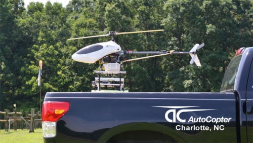
The AutocopterTM UAV
Recently, Agriculture and Agri-food Canada (AAFC) selected ING Robotic Aviation to demonstrate a new method for assessing crop vegetation using a Responder Robotic Rotary wing aircraft equipped with a Tetracam Mini MCA-6 sensor. The Responder can cover 1,000 ha within 25 minutes.
Data can be collected throughout the season, and at key decision points, to reveal changes, trends, patterns and anomalies within fields.
Rules and regulations
Legislation regarding the use of UAVs for commercial purposes is complex, and varies across the world. Transport Canada has been responsible for regulating the use of UAVs for commercial purposes in Canada since 2008. The legislation means that an operator can apply for a Special Flight Operations Certificate (SFOC) to fly a vehicle within a specified area. In November 2014 Transport Canada announced amendments to the regulations which will mean that certain operations with UAVs under 25 kg will not require a SFOC, and that those under 2 kg will be exempt altogether. These changes are expected to provide a further boost to the industry within Canada, and there are already a number of UAV operators providing commercial services for farmers.
In the United States, the use of UAVs for commercial purposes is currently banned, and this difference in the legal environment is currently putting Canada ahead in terms of the development of UAVs for agriculture. However, the US regulations are expected to be relaxed in 2015.
Back on the ground, tractors using auto-steer technology can already reduce spray and tillage overlap, saving inputs and reducing environmental impacts. Just as the concept of an unmanned aircraft is developed, driverless vehicles are emerging. The technology has existed for some time; however, legal safeguards will keep them off public roads for some time, as legislation catches up with technology. On privately owned farms and fields, there are few restrictions, and farming is an area where we will almost certainly see driverless or unmanned land vehicles emerging. Major agricultural engineers such as Agco, are now seriously looking at the potential for unmanned tractors for a range of basic operations. In time those operations requiring more skill could be performed by robots, and this is perhaps where the greatest benefits will be. Robots applying inputs such as fertilizer, herbicides etc. will be able to tailor precise applications to exactly where they are needed, eliminating human error. They may work with the aid of soil and crop maps prepared by UAVs, or they also may be able to gather data themselves. The Carnegie Mellons Robotics field centre based in Pittsburgh is currently testing an automated utility cart, equipped with laser range sensors, which will enable it to navigate through an orchard towing sensors which are able to track the progress of the crop. Robotics may allow machines to be downsized, thus reducing soil compaction with multiple machines running remotely from a computer within a farm office.
Keeping tabs on livestock
Precision crop farming is rapidly becoming the norm in many countries; but, the livestock sector is not to be left out. Forage and feed production can undoubtedly benefit from the same technology used for the production of other crops. Precision livestock farming also tailors feeding, healthcare and other management to the individual animal, through gathering electronic information.
There are a number of technologies which may be used within precision livestock farming. Monitoring animal movements with pedometers can provide important information on health and management. On dairy farms, pedometers can identify lame cows, and periods of heat activity. The use of ear tags and microchips is commonplace, and for some species in some countries it is compulsory for traceability purposes. Eartags provide information on body temperature, whilst boluses can monitor body temperature, and provide measurements of rumen ph. using wireless technology. Collars are available which can indicate heat and rumination activity. Robotic milking machines have been commercially available, and used on dairy farms for some time, where individual milk yields can be recorded, and cows individually rationed. Ranchers can use remote sensing to identify areas of over/under grazing on pasture land, or areas of weed infestation.
Readers collect the data with appropriate software for processing and recording, and the information can be used for a variety of management purposes such as rationing, breeding policies and health care decisions.
New technology is often the product of research institutes and academia, and it can be a very slow and difficult process to get it commercialized. Farmers will still need to take care and carry out a proper appraisal of any investment in new technology. The cost of the technology will be critical in determining its adoption. As more precision technology is adopted the capital costs would be expected to come down.
Growing agricultural trade and increased competition, rising labour costs, along with the increasing scarcity of fossil fuels will mean that precision agricultural technologies may become key to maintaining the competitiveness of Canada’s agricultural sector, and in meeting the many challenges of farming in the twenty-first century.